Australia Storm Book
Severe StormsFACTS, WARNINGS AND PROTECTION | Information from the BoM |
This information on Severe Storms in Australia is provided by the Bureau of Meteorology and Emergency Management Australia. It is divided in to six sections:
- Characteristics of severe storms
- Which storms are severe storms
- Examples of severe storms in Australia
- The Australian Severe Storm Warning Service,
- Protection from severe storms
- Protection against lightning strikes
- Which storms are severe storms
Characteristics of severe storms
Severe storms are very localised events, not usually affecting wide areas as tropical cyclones and floods do, so their devastating impact is often under-estimated. These storms can occur anywhere in Australia and do so much more frequently than any other major natural hazard. On average, each year severe storms are responsible for more damage (as measured by insurance costs) than tropical cyclones, earthquakes, floods or bushfires. Unfortunately, storms also kill people; between five and ten deaths are caused by lightning strikes each year. Deaths also occur when strong winds cause tree limbs to fall, debris to become projectiles and small boats in open water to capsize. In fact, although many people believe that tornadoes do not occur in Australia, 41 tornado-related deaths have been recorded here.Which storms are Severe Storms?
Severe storms can be divided into two types: severe thunderstorms; and land gales. Severe thunderstorms are more common, and generally more dangerous than land gales, which are described later.Severe thunderstorms
They are defined by the Bureau of Meteorology as those thunderstorms which produce either:- hailstones with diameter of 2cm or more; or
- wind gusts of 90 km/h or greater; or
- flash-floods; or
- tornadoes; or
- any combination of the above.
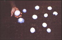
Hail
Hail stones form in a thunderstorm when raindrops freeze at high levels and then grow steadily in size as they are recycled
through powerful up- and down-draughts. Hailstones larger than cricket balls have been recorded in Australia. (Injury to people
and severe damage to buildings or vehicles can be caused by hailstones much smaller than these!)
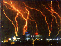
Lightning and thunder
Lightning is the discharge produced when differences between ground and atmospheric electrical charge are large enough
(several hundred million volts) to overcome the insulating effect of the air. Lightning strokes can occur within the cloud, between
clouds or between clouds and the ground. An average thunderstorm can release several hundred megawatts of electrical power.
Thunder is the sound produced by the explosive expansion of air heated by the lightning stroke to temperatures as high as
20,000 C.
Wind Gusts
In a mature thunderstorm, falling rain and hail drag surrounding air downwards. Also, evaporation from raindrops cools nearby
air, accelerating the downward rush. This strong downdraught spreads out upon reaching the ground, producing a cool, gusty wind
which can cause damage.
Flash-Floods
The updraught of a mature thunderstorm produces rain drops through the condensation of moist air which cools as it rises.
When rain drops become too large to be supported they fall, but the intense updraught of a severe storm can suspend huge
amounts of rain before releasing a deluge onto the ground. Such rain can reach intensities of more than 200 millimetres per hour,
provided the environment is humid enough to feed sufficient moisture to the storm. Flash-floods often result when the storm moves
slowly, so that a small area receives most of the rain, but drainage and run-off characteristics on the ground can also control where
the greatest impact occurs.
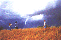
Tornadoes
These rarest and most violent of thunderstorm by-products are rapidly rotating columns of air that descend in the well-known
funnel shape from the base of the storm cloud. A tornado vortex can range in width from a few metres to several hundred metres,
usually whirls clockwise (seen from above) and contains winds that may reach more than 450 km/h.
What causes severe thunderstorms?
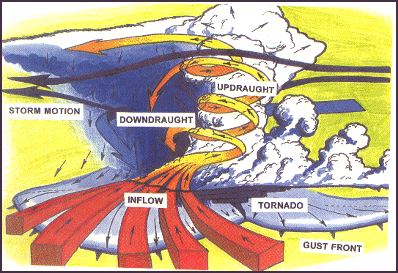
Thunderstorms develop when dense cold air overlies warm, moist air, which is less dense. A 'trigger' such as solar heating, a front, or a trough can then begin the development of a thunderstorm. Strong upward currents of air develop and heat energy stored in the air and water vapour is converted into wind and electrical energy. When the atmosphere is especially unstable and the surrounding wind flow happens to be arranged to provide the most efficient input of energy to a growing cloud, a severe thunderstorm develops with well-organised, complementary up- and down-draughts.
Where and when do severe thunderstorms strike?
Severe thunderstorms can occur throughout the year, although they are very rare during the dry winter months in the north. Most strike from September to March when the supply of solar energy is greatest, but severe winter storms linked to cold fronts are common in the south west of WA.
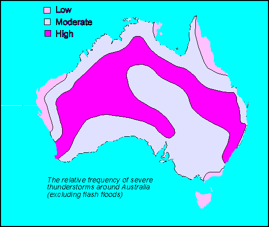
The geographical spread of severe thunderstorms in Australia is difficult to determine because of our low population density and lack of observations over most of the continent. While records of storm impacts show that the most damaging storms have occurred in the populous south east quarter of the continent, analysis of wind, hail and tornado data suggests that severe thunderstorms are a significant threat throughout the Country. The most damaging individual storms have hit south eastern Queensland and the central NSW coast.
Land gales
Land gales are simply gale force winds (62 km/h) or stronger over the land, and usually affect a much wider area and last much longer than thunderstorms. Gales blow when large differences in atmospheric pressure are concentrated over a small distance. This can happen between 'deep' low pressure systems and strong highs or near intense cold fronts.
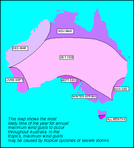
In the southern half of Australia extreme winds generally occur in winter and spring and are usually due to land gales. In the tropical north, the strongest winds usually hit in summer and autumn, and are often due to tropical cyclones.
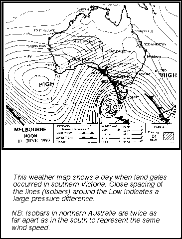
Examples of Severe Storms in Australia:
(Total cost estimates include uninsured property and infrastructure damage in '1993 dollars')
29 November 1992
A tornado and larger than golf-ball hail tear through Bucca, north of Bundaberg, Queensland, levelling three homes and unroofing many others, as well as ruining millions of dollars worth of crops.
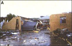
22 November 1992
During the early hours of the morning, a tornado severely damages over a dozen houses, destroying several in the
north west Tasmanian town of Smithton. It is the State's most intense tornado, with estimated winds of 280 km/h which also
flatten hundreds of large trees along a 15 km path. (photo A)
22 January 1991
A tornado and hail cause a total estimated $75 million worth of damage in Adelaide, the worst natural disaster since
Ash Wednesday bushfires of 1983.
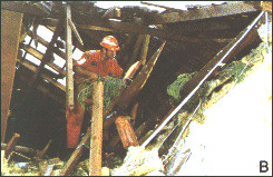
21 January 1991
The most damaging thunderstorm in Australia's history batters the north shore of Sydney with wind gusts estimated at 250 km/h,
large hail and torrential rain. One hundred people were injured and the total cost was over $560 million. (photo B)
18 March 1990
Sydney is pelted with giant hailstones, which injure 25 people and result in total damage costs estimated at $400 million which includes thousands of dented cars.
23 November 1987
Gales buffet central Victoria, stretching State Emergency Service resources to the limit. The estimated damage cost is more than $30 million.
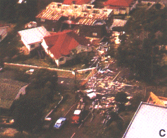
18 January 1985
A severe wind and hailstorm passes over Brisbane lifting roofs, breaking windows and damaging cars. In just thirty minutes,
damage estimated at $307 million is done and 20 people are injured. (photo C - courtesy of Channel 7 News, Brisbane)
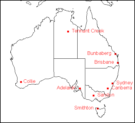
13 January 1976
Near Sandon in central Victoria, two people are killed when a tornado plucks their car from the side of the road and hurls it 100 metres into a ditch.
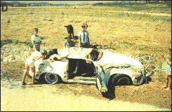
26 January 1971
Thunderstorms dump torrential rain on the Australian Capital Territory. Widespread severe flash-flooding causes seven people
to drown, mainly as a result of their vehicles being swept away in Woden Valley, Canberra. (photo D)
12 December 1961
A severe thunderstorm blasts Tennant Creek in the Northern Territory with winds measured at 193 km/h. This makes it the highest confirmed non-cyclonic gust ever observed in Australia.
6 April 1960
In the early hours of the morning, a tornado sweeps through dense Jarrah forest near Collie in the south west of Western
Australia, cutting a swathe averaging 240 metres wide along a continuous track of 30 kilometres. Tens of thousands of trees
are left felled in its wake.
The Australian Severe Storm warning service...
The Bureau of Meteorology is responsible for provision of warnings of dangerous weather to the Australian community, with the aim of minimising injury and damage. The service is provided from Regional Forecasting Centres of the Bureau in State and Territory capitals, and information is transmitted to authorities such as Police, State and Territory Emergency Services and to radio and television stations. Forecasters use data from satellites, radar, lightning detection networks and ground-based observations together with computer models to prepare the warnings.The most recent warnings around the country are available from the Weather & Flood Information page. Region - specific warnings are available from the regional pages. Ah the moment, there are Warnings current in: Western Australia , Tasmania , New South Wales / Australian Capital Territory , Queensland , Victoria , South Australia .
... for severe thunderstorms:
With lifetimes of three hours or less and diameters of as little as ten kilometres, severe thunderstorms are especially difficult to monitor and predict. Radar is necessary to track and forecast the storms with precision, limiting both the area where a detailed and specific service is possible, and the lead time which can be given. The Bureau therefore provides a two-tiered service:(i) Short-term warning (up to three hours ahead) for capital cities and their immediate surrounds, whenever severe thunderstorms are detected or imminent. Warnings contain information about phenomena expected with the storm (hail, wind etc), suburbs likely to be affected and direction of movement of storm cells. Forecasters aim to provide at least 30 minutes warning of onset of these storms.
SEVERE THUNDERSTORM WARNING
BUREAU OF METEOROLOGY, SYDNEY
Issued 1700 hours on Friday 26/3/93

Severe thunderstorms with severe wind gusts, damaging hail, and very heavy
rain are expected during the next hour in the following Council areas:

SYDNEY METROPOLITAN

A LINE OF THUNDERSTORMS EXTENDING FROM JUST NORTH OF PENRITH EASTWARDS TO
THE COAST AT 5PM HAS PRODUCED HAIL UP TO 2 OR 3CM IN DIAMETER AND STRONG
WINDS IN SOME SUBURBS. THESE STORMS ARE EXPECTED TO PERSIST FOR AT LEAST
THE NEXT HOUR.

The State Emergency Service advises you to:
. put your vehicle under cover
. stay inside away from windows
. ring your local SES unit for emergency assistance if your house is damaged.
(ii) Longer-term advices (up to six hours ahead) for the capitals and provincial areas. The extent of the area covered by the longer-term service varies from State to State, depending on the local characteristics and predicability of thunderstorms. For example, an advice service is not feasible in the tropics because of the high frequency of 'ordinary' thunderstorms during the 'wet season' and the lack of reliable forecasting clues such as triggering fronts. Where the advice service is provided, it includes information about the expected phenomena, but the location and timing of the storms are predicted in more general terms than are used for warnings. In the capital city areas the advice service should alert the public to the need to listen for warnings later in the day.
SEVERE THUNDERSTORM ADVICE
BUREAU OF METEOROLOGY, PERTH
Issued at 1245 hours on Saturday 1/5/93
FOR THE INLAND PARTS OF THE WEST GASCOYNE.

SEVERE  THUNDERSTORMS ARE POSSIBLE DURING THIS  AFTERNOON AND EVENING.
WIND GUSTS  IN  EXCESS OF 90 KM/H, HAIL AND FLASH FLOODING MAY RESULT
IN DAMAGE TO PROPERTY.
...and for land gales:
Land Gale Warnings are issued on a district scale throughout the Country. Because land gales affect larger areas and last longer than thunderstorms, these warnings generally cover periods of six to twelve hours and are not as specific or detailed as severe thunderstorm warnings. Because the warning services are tailored to local needs there are some differences in presentation around Australia. More information on details of your local service can be obtained from the Regional Office of the Bureau in your capital city.
LAND GALE WARNING BUREAU OF METEOROLOGY MELBOURNE
Issued 1130 hours 11/10/92

NORTH TO NORTHWESTERLY WINDS OF 30 TO 40 KNOTS ARE EXPECTED TO DEVELOP OVER THE CENTRAL
DISTRICT OF VICTORIA THIS AFTERNOON AND PERSIST INTO TONIGHT.
Protection from Severe Storms
- Before the storm season
- As the storm approaches
- When the storm arrives
- After the storm passes
- Emergency assistance
- As the storm approaches
- Trim tree branches well clear of your house.
- Have a portable radio and torch with fresh batteries.
- Have a first aid kit (and basic knowledge).
- List your emergency contact numbers. . Clear yard of loose objects.
- Clean and check roof, guttering and downpipes.
- Familiarise your family with this storm action guide.
- Have masking tape (for glass), plastic sheeting and large garbage bags (for emergency rain protection).
- Stay inside and shelter well clear of windows, in the strongest part of the house (bathroom, cellar).
- If necessary, cover yourself with a mattress, blanket, doona or tarpaulin, under a table or bench etc.
- Listen to your portable radio for storm updates.
- If outdoors find emergency shelter (see lightning protection).
- If driving, stop clear of trees, power lines or streams.
- Avoid using the telephone during the storm (see lightning protection).
- Check your house for damage.
- Listen to your local radio station for official warnings/advice.
- If you need emergency assistance, consult '(e) Emergency Assistance' guide (opposite).
- If you don't need help, check your neighbours.
- Beware of fallen power lines, damaged buildings and trees and flooded watercourses.
- Don't go sight-seeing, stay home and help others.
-
STATE/TERRITORY EMERGENCY SERVICE
- Call your nearest unit for emergency assistance with house damage, and/or advice about temporary accommodation, food and clothing.
- ELECTRICITY AUTHORITY
- Call your local office for power failure, fallen power lines, or other electrical problems.
- WATER BOARD/AUTHORITY
- Call your nearest depot if your household water supply is damaged or interrupted.
- GAS COMPANY/AUTHORITY
- Call your local office for gas emergencies.
- INSURANCE COMPANY
- Call immediately, to arrange approved tradespeople to repair your home. This is your responsibility.
- POLICE, FIRE, AMBULANCE
- Listen to radio for official warnings/advice.
- Form a self-help group with family and neighbours.
- Watch for emergency services crews who will check your area as soon as possible.
Protection against Lightning Strikes
In statistical terms, lightning poses a greater threat to individuals than almost any other natural hazard in Australia, accounting for five to ten lives and well over 100 injuries annually. These figures are likely to steadily increase in line with the growing proportion of retired people, many of whom are frequently engaged in outdoor, recreational activities such as golf, fishing, boating etc.
Of the many lightning strike injuries each year, about 80 are due to people using normal telephones during thunderstorms when the phone system may suddenly become part of a highly charged electrical circuit. Related injuries may include hearing damage, burns, or even electrocution (see 'Indoors protection').
During thunderstorms the following precautions should be taken:
- Seek shelter in a 'hard top' vehicle or building - avoid small structures, fabric tents and isolated or small groups of trees.
- If in the open away from shelter, crouch down (singly), preferably in a hollow, with feet together and remove metal objects from head and body. Do not lie down but avoid being the highest object in the vicinity.
- If you hair stands on end or you hear buzzing from nearby rocks, fences etc, move away to a new position immediately.
- Don't fly kites or model planes with control wires.
- Don't handle long or metallic objects such as fishing rods, umbrellas and golf clubs in the open.
- Don't touch or move close to metal structures, wire fences or metal clothes lines.
- Don't ride horses, cycles or drive in open vehicles.
- If driving, slow down or park away from trees, power lines etc. Stay inside metal-bodied (hard top) vehicles or caravans but do not touch or lean on metal body components.
- If swimming or surfing leave the water immediately and seek shelter.
- If boating etc, get ashore as soon as possible. If unsafe to do so, seek protection beneath a high structure such as a bridge or jetty.
- Be sure the mast and stays of a sailing boat are adequately 'grounded' to the water.
- Keep clear of windows, electrical appliances, pipes and other metal fixtures.
- Avoid use of telephones. If an emergency call is required, make it brief, don't touch any metal, brick or concrete and don't
stand bare foot on concrete or tiled floors.
- Before the storm arrives, disconnect external aerial and power leads to radio and television sets.
- Disconnect computer modems and power sources, then stay away from electrical appliances.
- Apply immediate heart massage and mouth-to-mouth resuscitation to lightning victims continuously until medical help arrives and they will have a good chance of survival.
- When struck, people do not glow or 'fry to a crisp' but the heart and breathing are often affected.
- Only about 30% of people struck, actually die, and the incidence of long term disability is low, particularly when first-aid is applied promptly.
- If your clothes are wet, you are less likely to be seriously injured if struck, as most of the charge will conduct through your wet clothes rather than your body.
- Lightning can, and often does, strike more than once in the same place.
- Worldwide, thunderstorms are producing approximately 6,000 lightning strikes every minute.
The information presented here is also available in Australia as a colour brochure from your local State/Territory Emergency Service or your local regional office of the Bureau of Meteorology.
Page 6